Polar Ice Basics
It is very important to understand that there are two basic types of ice: land ice and sea ice.
Land (continental) ice is formed by the gradual build up and compaction of snow, resulting in ice sheets that are hundreds to thousands of feet thick. Continental ice, normally called glaciers, comes from "fresh" water that has fallen as precipitation, most likely snow. It contains no salt. When it accumulates or melts, it highly influences global sea levels which rise and fall over thousands of years.
Sea ice is completely different. It is the thin layer of ice that forms on the surface of the ocean, typically 3 to 6 feet thick, when "salty" sea water is cooled enough by the atmosphere. The point where sea water turns to ice is about 29 degrees Fahrenheit. Sea ice moves with the winds and currents, continuing to grow both by freezing and through collisions with other ice floes (ice sheets floating in the water). When the atmosphere warms the ocean again in its next cycle, such as in spring, or if the sea ice has moved sufficiently towards the equator, the sea ice melts again. Almost all sea ice melts every year, only a small portion lives through each summer. The building and thawing of sea ice has only a minor affect on global sea levels as roughly the same amount of water freezes that eventually melts.
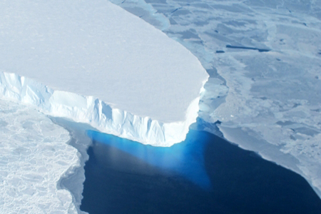
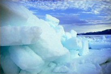
In the picture above, a piece of glacier is shown in the upper left hand portion. Glaciers are not stationary, they slowly but surely flow towards an ocean. They grow every winter and melt some every summer. Surrounding the glacier is sea ice and some water. The sea ice was not made from the glacier, it was made by the nearby frozen salt water. It is much smaller in height than the glacier and comes in smaller pieces that are floating. Some parts of a glacier may be above the water, but the glacier is anchored back on land. Some pieces of the glacier do occasionally break off (called calving) and then float away and eventually melt. However the following winter back on land, the glacier will grow again and slowly drift back towards the sea. Top
Glacier Overview
Glaciers are made up of fallen snow that, over many years, compresses into large, thickened ice masses. Glaciers form when snow remains in the same area year round, and enough snow accumulates to transform itself into ice.
Each year, new layers of snow bury and compress the previous layers. This compression forces the snow to re-crystallize, forming grains similar in size and shape to grains of sugar. Gradually the grains grow larger and the air pockets between the grains get smaller, causing the snow to slowly compact and increase in density.
After about two winters, the snow turns into "firn", an intermediate state between snow and glacier ice. At this point, it is about half as dense as water. Over time, larger ice crystals become so compressed that any air pockets between them are very tiny.
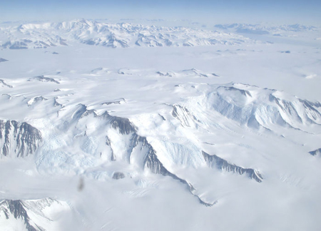
In very old glacier ice, crystals can reach several inches in length. For most glaciers, this process takes over a hundred years. See the glacier with huge mountain ridges in central Antarctica to the left. What makes glaciers unique is their ability to move and flow like extremely slow rivers. Top
Glacier Features
Glaciers live a dynamic existence. Some glaciers are as small as football fields, while others grow to be over a hundred miles long. Snow falls in the "accumulation" area, usually the upper part of the glacier with the highest elevation and no melting season. The new snow adds to the glacier's overall mass. As the snow accumulates and turns to ice, the increase in the glacier's weight forces glacial movement.
Much further down the glacier is the "ablation" area, where most of the melting and evaporation occurs. Between these two areas a balance is reached, where snowfall equals snowmelt. Here, the glacier is in equilibrium. Whenever this equilibrium is disturbed, either by increased snowfall or by excessive melting, the glacier either retreats or advances at more than its normal pace.
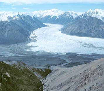
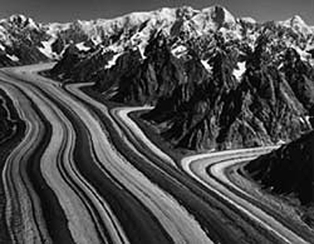
The sheer weight of a thick layer of ice being tugged by gravity, and the fact that it deforms like a "plastic" material, causes glaciers to flow very slowly. Ice may flow down mountain valleys, fan across plains, or in some locations spread out to the sea. See the photo at the left of the Donjek Glacier in Canada flowing like a river.
Common glacial features are "moraines", created when the glacier pushes or carries along rocky debris as it moves. These long, dark bands of debris are visible on top and along the edges of glaciers. Medial moraines run down the middle of a glacier, lateral moraines along the sides, and terminal moraines are found at the snout (end) of a glacier. See the Barnard Glacier in Alaska. to the left.
At locations where a glacier flows rapidly, giant cracks called "crevasses" are created. These can make travel across a glacier treacherous. Also, underneath the glacier where glacier ice meets the ground, large amounts of rock and soil are ground up by the tremendous weight of the glacier.
Glaciers occupy about 10 percent of the world's total land area, with most located in polar regions like Antarctica and Greenland. Glaciers can be thought of as remnants from the last ice age, when ice covered nearly 32 percent of the land, and 30 percent of the oceans.
Within the past 750,000 years, scientists know that there have been eight ice age cycles, separated by warmer periods called interglacial periods. Currently, the earth is nearing the end of an interglacial, meaning that another ice age is due in about a thousand years. This is part of the normal climate variation cycle. Top
Sea Ice
Even though sea ice occurs in the polar regions, it influences our global climate. Sea ice has a bright surface, so, much of the sunlight that strikes it is reflected back into space. As a result, areas covered by sea ice don't absorb much solar energy, so temperatures in the polar regions remain relatively cool.
If gradually warming temperatures melt sea ice over time, fewer bright surfaces are available to reflect sunlight back into space, more solar energy is absorbed at the surface, and temperatures rise further. This chain of events starts a cycle of warming and melting. This cycle is temporarily halted when polar winters return, but it starts again in the following spring. Even a small increase in temperature can lead to greater warming over time, making the polar regions the most sensitive areas to climate change on earth.
Sea ice also affects the movement of ocean waters. When sea ice forms, most of the salt is pushed into the ocean water below the ice, although some salt may become trapped in small pockets between ice crystals. Water below sea ice has a higher concentration of salt and is more dense than surrounding ocean water, and so it sinks. In this way, sea ice contributes to the ocean's global "conveyor-belt" circulation. Cold, dense, polar water sinks and moves along the ocean bottom toward the equator, while warm water from mid-depth to the surface travels from the equator toward the poles. Changes in the amount of sea ice can disrupt normal ocean circulation, thereby leading to changes in global climate. For more information on the Great Ocean Conveyor Belt click here.
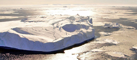
The difference between sea ice and icebergs is that sea ice forms from salty ocean water, whereas icebergs form from fresh snow. Sea ice grows, forms, and melts strictly in the ocean. Icebergs are chunks of ice that break off from glaciers and fall into the ocean.
Fresh water is unlike most substances because it becomes less dense as it nears the freezing point. This difference in density explains why ice cubes float in a glass of water.
The salt in ocean water causes the density of the water to increase as it nears the freezing point, and very cold ocean water tends to sink. As a result, sea ice forms slowly compared to freshwater ice because salt water sinks away from the cold surface before it cools enough to freeze. The freezing temperature of salt water is lower than fresh water; ocean temperatures must reach -28.8 degrees Fahrenheit to freeze. Because oceans are so deep, it takes longer to reach the freezing point, and generally, the top 300 to 450 feet of water must be cooled to the freezing temperature for sea ice to form. Top
Sea Ice Formation
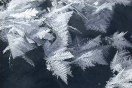
As the ocean water begins to freeze, small needle-like ice crystals called "frazils" form. These crystals are typically 0.12 to 0.16 inches in diameter. Because salt does not freeze, the salt works its way on its own out of the crystals into the water. Frazil crystals are almost pure fresh water. Sea ice forms when frazil crystals float to the surface, accumulate and bond together forming a sheet of ice. One of the features on the surface of sea ice are "frost flowers", crystals of ice deposited on the sea ice when water vapor bypasses the liquid phase and becomes a solid. See the image to the left of frost flowers.
In calm waters, frazil crystals form a smooth, thin form of ice, called grease ice for its resemblance to an oil slick. Grease ice develops into a continuous thin sheet of ice. Eventually, the ice thickens into a more stable sheet with a smooth bottom surface. The thin sheet is initially a dark color, but it becomes whiter as it thickens.
If the ocean is rough, the frazil crystals accumulate into circular disks, called pancakes because of their shape. A signature feature of pancake ice is raised edges on their perimeter caused by the pancakes bumping into each other by ocean waves. If the motion is strong enough the pancakes slide over each other, which is called rafting. If the ice is thick enough, ridging occurs where the sea ice fractures and piles on top of itself forming lines of ridges on the surface. See the photo to the left of sea ice ridges.
Each ridge has a corresponding structure, called a keel, that forms on the underside of the ice. Particularly in the Arctic Ocean, ridges up to 60 feet thick can form. Eventually, the pancakes cement together and consolidate into a large ice sheet. Unlike the grease ice which has a smooth bottom surface, pancake ice has a rough bottom surface.
Sea ice is usually covered with snow, which insulates the ice and delays melting in the summer. Except during the melting season, the snow is usually dry, wind-blown, and hard-packed. Wind from a consistent direction can blow snow into ridges parallel to the wind direction, just like small sand dunes. These complex, fragile shapes are called "sastrugi". Top
Arctic vs. Antarctic Sea Ice
Because both the Arctic and Antarctic are cold, dark, and remote, we often think these two places are somewhat the same. However, they are quite different. Sea ice differs between the Arctic and Antarctic, primarily because of their different geography. The Arctic is a semi-enclosed ocean, almost completely surrounded by land. As a result, the sea ice that forms in the Arctic is not as mobile as sea ice in the Antarctic.
Although sea ice moves around the Arctic basin, it tends to stay in the cold Arctic waters. Floes are more prone to bump into each other and pile up into thick ridges. These converging floes makes Arctic ice thicker. The presence of ridge ice and its longer life cycle leads to ice that stays frozen longer during the summer melting. So, some Arctic sea ice remains through the summer and continues to grow the following autumn.
The Antarctic is almost a geographic opposite of the Arctic, because Antarctica is a land mass surrounded by an ocean. The open ocean allows the forming sea ice to move more freely, resulting in higher drift speeds.
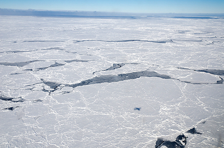
However, Antarctic sea ice forms ridges much less often than sea ice in the Arctic. Also, because there is no land boundary to the north, the sea ice is free to float northward into warmer waters where it eventually melts. As a result, almost all of the sea ice that forms during the Antarctic winter melts during the Antarctic summer.
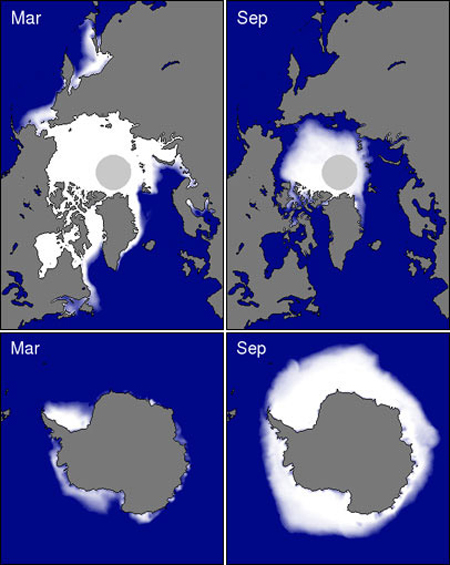
The images to the left using satellite sea ice concentration data show average minimum and maximum sea ice during March and September for the Arctic and Antarctic over 20 years. Because sea ice does not stay in the Antarctic as long as it does in the Arctic, it does not have the opportunity to grow as thick as sea ice in the Arctic. While thickness varies significantly within both regions, Antarctic ice is typically 3 to 6 feet thick, while most of the Arctic is covered by sea ice 6 to 9 feet thick. Some Arctic regions are covered with ice that is 12 to 15 feet thick. Top
Arctic Warming
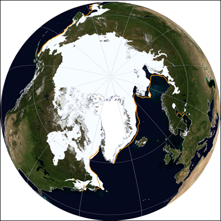
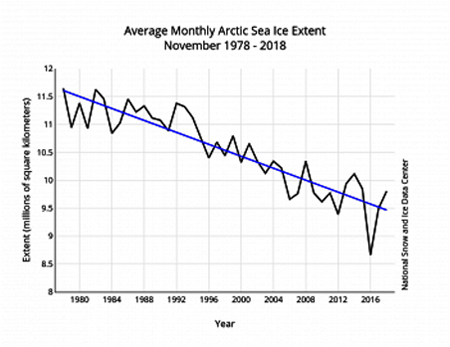
A study by researchers from the National Snow and Ice Data Center (NSIDC) at the University of Colorado in Boulder shows that the annual Arctic sea ice hit its maximum coverage on March 21st, 2014 and began its annual summer meltdown. See the NASA maximum extent (covered ice area) image to the left. In September of each year, the Arctic sea ice extent reaches its minimum due to summertime melting. See the minimum extent illustration to the left below.
The summer sea ice minimum extent from one year to the next jogs up and down. However, the long term trend is downward and has recently dropped more steeply. From 1979 to 2001, the September minimum had dropped by about 7 percent per decade. However, the trend from 1979 to 2013 was a loss of 14 percent per decade - twice as much.
The trend for the winter maximum sea ice is also down, but the decrease is not nearly as steep as that of the minimum - about a 2.6 percent decline per decade. Why is the trend less? It is probably due to the thickness of the ice.
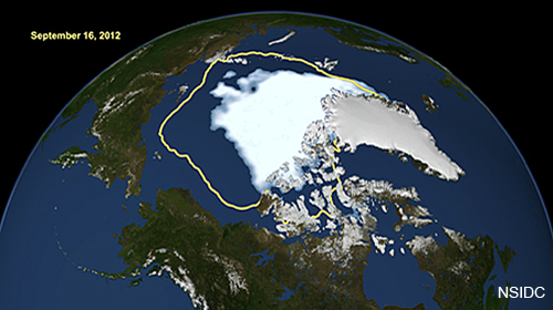
The length of the melting season for Arctic sea ice is growing by five days each decade. An earlier start to the melting season allows the Arctic Ocean to absorb enough solar radiation to melt as much as four feet of the Arctic ice cap thickness. See the image to the lower left, which shows the average 30 year extent from 1981 to 2010 in yellow versus the 2012 extent in white.
The Arctic is warming and this is causing the melting season to last longer. The lengthening of the melting season allows more of the sun’s energy to get stored in the ocean and increases ice melting during the summer. The thickness and age of the ice are also very important for ice longevity. Thin ice is usually comprised of ice that formed during a single winter freeze season, called seasonal ice. Seasonal ice easily melts and is therefore unlikely to survive a melting season. Multi-season ice, which is thicker and more resilient, is able to survive a melting season. Thicker, multi-year ice appears to have survived the 2013 melting season with a 10 percent increase.
In the mid 1980s at least 60 percent of the ice was multi-year (and thus thicker) ice, but by the end of 2012 that had dropped to only 30 percent. With a greater percentage of seasonal ice at the beginning of the melting season, we see a greater percentage of ice melting by the time we get to the season's end in September. The 2014 maximum extent on March 21 was almost two weeks later than the average - sea ice typically peaks around March 9. The melting was delayed by a late cold weather pattern that increased both the length of the winter season and the extent of the sea ice causing a significant uptick in sea ice growth.
Over the last four decades the Arctic sea ice cover is shrinking and thinning, making scientists think a total ice free Arctic Ocean during the summer might be reached this century. The seven lowest September sea ice extents in the satellite record have all occurred in the past seven years (2007 to 2013). Results show that although the melting season is lengthening at both ends, with an earlier melting in the spring and a later freeze in the fall, the predominant phenomenon extending the melting is the late start of the freeze season.
In the winter, sea ice currently extends about 6 million square miles, shrinking in summer and growing back in the fall. Satellite data analyzed by NSIDC show that the Arctic sea ice extent shrunk and set a new low summer record of 1.3 million square miles in 2012. See the Arctic sea ice extent time graph to the left.
Normally sea ice in the Arctic reaches its minimum in mid-September and then starts refreezing. The new record minimum set in 2012 measures about 300,000 square miles (the state of Texas is about 269,000 square miles) less than the previous low extent of 1.6 million square miles set in September 2007. The minimum extent in 2012 was approximately half the size of the average extent from 1979 to 2000 and was the first time the extent covered less than 2.5 million square miles.
Although the loss of thin layers of sea ice do not tell us much about the overall state of ice loss in the Arctic Ocean, it does tell us a great deal about albedo, the property of sea ice to reflect heat back into space. When sea ice diminishes, more heat passes into the oceans. This extra heat melts some of the thick ice and speeds up the melting of thinner sea ice. This allows more heat to accumulate in the oceans, which is an example of a positive climate feedback. Top
Is Antarctic Ice Increasing Or Decreasing?
Is overall Antarctic "land ice" decreasing? The answer is probably no. An October, 2015 NASA study stated that an increase in Antarctic snow accumulation that began 10,000 years ago is "adding enough ice to the continent to outweigh" the increased losses from its thinning glaciers. The research challenged the conclusions of other studies, including the 2013 IPCC report, which said that Antarctica is overall losing land ice.
However in the summer of 2017, Jay Zwally, NASA's chief cryospheric scientist and the chief author of the 2015 study, said that "Now we’re very close to the zero line". The melt rates in West Antarctica have recently increased significantly. His calculations now show that the continent is about in overall balance. The findings haven’t been peer reviewed yet, but he plans to present them at a science conference in the near future.
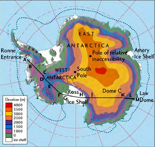
Antarctica is not a simple continent. It divides into two distinct areas. East Antarctica is a huge mountainous area about the size of Australia completely covered by ice and very cold with no summer melting. In the chart to the left, East Antarctica is the area surrounded by "purple color". About 70% of the earth's fresh water is stored as ice in East Antarctica.
West Antarctica is much smaller and relatively flat with melting summers. West Antarctica is a collection of islands (like Hawaii) that are covered with ice and inhabited by penguins.
If all the ice in East Antarctica melted, it would raise sea levels by an amazing 200 feet. If all the West ice melted, seas would rise only about 20 feet. The dynamic process of solid ice flowing downhill to the sea with very little surface melting is what enables East Antarctica to continue gaining mass.
Although it is now hard to imagine, Antarctica was once a lush tropical forest 52 million years ago when average temperatures were about 68°F, about 14°F more than the current average US temperature (avg. US temperature is 52.4°F, record year was 2012 with 55.3°F). Palms, ferns and trees typical of warm, lowland rainforests made up the landscape as revealed by sediments from ice core drilling.
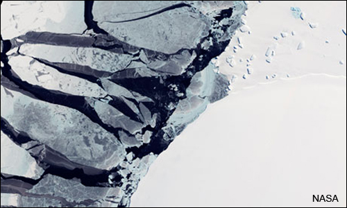
The West Antarctic Ice Sheet (WAIS) is actually sitting on the floor of the Southern Ocean, not on dry land. Parts of it are more than one mile below sea level. Scientists at NASA’s Jet Propulsion Laboratory (JPL) found that the "grounding line", the line between the glacier's floating section and the part of the glacier that rests on the sea floor, has been rapidly retreating towards land. This means that the West Antarctica glacier is losing mass and in fact the loss is accelerating. Ice "shelves" are the part of a glacier that extend beyond the grounding line towards the ocean and they are the most vulnerable part of a glacier due to warming seas.
A theory in glaciology is that ice shelves buttress (support the end wall of) glaciers with their large mass slowing the ice movement towards the sea. Thinning of the ice shelf reduces its buttressing effect on the glacier behind it, allowing the glacier flow to speed up. Also, the melting of the underside of an ice shelf precedes its collapse. The above picture from a NASA satellite shows the West Antarctic ice shelf crumbling.
Why is sea ice increasing slightly? One theory is that the increase of the size of the hole in the South Pole ozone layer strengthened surface winds in Antarctica and deepened storms leading to more cold air over West Antarctica. This in turn has caused a greater northward movement of sea ice and the extent of the Antarctic sea ice. Another theory is that the amount of freshwater in the Southern Ocean has increased, diluting the salt content of the seawater and altering ocean circulation patterns. At this point scientists are not certain exactly why Antarctic sea ice is increasing, but acknowledge that it is and there may be multiple causes.
In summary, the East Antarctica land ice mass is increasing but it has been hard to measure. West Antarctica land ice is decreasing rapidly. In total Antarctic "land ice" as a whole is in balance. Antarctic "sea ice" is growing, but why is not fully understood. However, sea ice increases in Antarctica do not make up for the accelerated Arctic sea ice loss of the last 3.5 decades a NASA study finds. As a whole, the planet has been shedding sea ice at an average annual rate of 13,500 square miles (35,000 square kilometers) since 1979, the equivalent of losing an area of sea ice larger than the state of Maryland every year.
Top