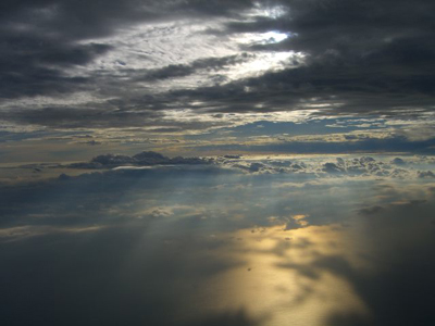
Our "Thin" Atmosphere
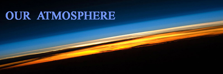
The above picture of the earth and our atmosphere was taken from the International Space Station while over the Indian Ocean at sunset. The vast majority of the atmosphere (about 80 miles in height) is only 1% the diameter of the earth which is roughly 8,000 miles. The different colors roughly correspond to the different layers of the atmosphere. The atmosphere becomes thinner and thinner with increasing altitude with no definite boundary at the top of the atmosphere and outer space. The deep oranges and yellows appear in the troposphere, which extends from the earth’s surface (dark black surface) 6 miles at the poles to about 10 miles at the equator. This layer contains roughly 80% of the mass of the atmosphere and almost all of the water vapor. Several dark clouds are visible within this layer. The variations in the oranges and yellows are due to different densities of clouds. The pink and white region is the stratosphere. This layer generally has no clouds and extends to approximately 30 miles above the surface. Above the stratosphere in the blue layers are the mesosphere, thermosphere, and exosphere which gradually fades into outer space. Gravity holds the atmosphere in place and is the reason the atmosphere is more dense closer to the earth's surface. Top
The Atmosphere's Layers
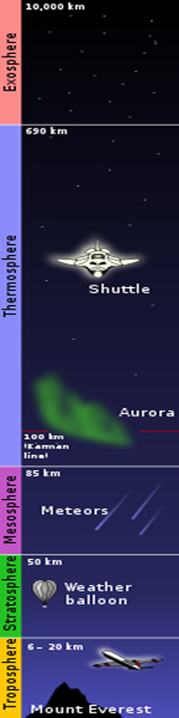
Exosphere. The outermost layer of Earth's atmosphere, the exosphere, is mainly composed of hydrogen and helium. The particles are so far apart that they can travel hundreds of miles without colliding with one another. Since the particles rarely collide, the atmosphere no longer behaves like a fluid. A molecule moving at escape velocity can travel into outer space with only a small chance of a collision. If it is moving below escape velocity, gravity will prevent it from escaping. The altitude of the lower exosphere boundary, the thermopause, ranges from 150 to 300 miles depending on solar activity. The thermopause is defined as the height above which there are negligible atomic collisions between particles. Since there is no clear boundary between the exosphere and outer space, the exosphere is considered by some to be part of outer space.
Thermosphere. The thermosphere is the largest of all the layers of the earth's atmosphere. The thermosphere begins about 50 miles above the earth and extends to 150 to 300 miles. As can be seen from the chart at the right, temperatures in the thermosphere "increase" with altitude even though at the thermosphere bottom they are an incredible 55 miles high! This is due to absorption of solar radiation by the small amounts of oxygen still present. Temperatures are very dependent on solar activity and the highly diluted gas varies from about 1,000 °F at night to about 4,000 °F during a day when the sun is very active. Even though the temperature can be very high, one would not feel any warmth in the thermosphere because it is so close to a vacuum that there are only a few atoms of gas to transfer heat.
Radiation causes the particles in the thermosphere to become electrically charged enabling radio waves to bounce off an invisible ceiling and to propagate beyond the normal horizon. The International Space Station and the space shuttles both orbit the earth in the middle of the thermosphere about 220 miles high. In addition, Auroras also occur in the thermosphere near the earth's north and south poles. Charged particles (electrons, protons, and other ions) from outer space collide with atoms and molecules in the thermosphere at high latitudes exciting them into higher energy states. These atoms and molecules shed their excess energy by emitting photons of light which we see as colorful auroral displays.
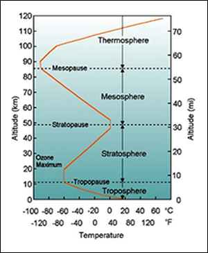
Mesosphere. Temperatures decrease with increasing altitude in the mesosphere (meaning middle sphere). This is due to decreasing reflective solar heating from the earth and increasing cooling from CO2 and other greenhouse gases. The top of the mesosphere, the mesopause, is the coldest place on earth. Temperatures in the upper mesosphere fall as low as −150 °F and vary according to latitude and season. The bottom of the mesosphere is the stratopause, which is the top of the stratosphere. The main features of the mesopause are strong winds containing tides and waves. Most of the tides and waves initiate in the troposphere (just above the land) and lower stratosphere and propagate upwards to the mesosphere. In the mesosphere, wave amplitudes can become so large that the waves become unstable and dissipate. This dissipation drives global air circulation. The mesosphere lies above the maximum altitude for aircraft and below the minimum altitude for spacecraft. It has been explored only through the use of rockets. As a result, it is the most poorly understood part of the atmosphere. Millions of meteors enter our atmosphere accumulating about 40 tons of material per day. Reaching the mesosphere, most meteors either melt or vaporize because of collisions with gas particles. The result is a high concentration of iron and other metals falling through the atmosphere and reaching the earth's surface.
Stratosphere. The stratosphere is the second layer of the atmosphere just above the troposphere at the earth's surface. It is stratified (built up of layers) in temperature, with warmer layers higher up and cooler layers further down. This is the opposite of the troposphere, which is cooler higher up and warmer further down. The border of the troposphere and stratosphere, the tropopause, is where the inversion begins. The stratosphere resides about 6 miles to 30 miles above the earth's surface. Temperatures increase as its altitude increases ranging from about -70 °F at its bottom to about +30 °F at its top, an increase of about 100 °F.
The temperature in the stratosphere increases because ozone (O3) absorbs harmful high energy ultraviolet light from the sun protecting life at the earth's surface. High energy ultraviolet light splits oxygen molecules (O2) apart by breaking the bonds between the atoms. Highly reactive free oxygen individual atoms (O) then collide with other oxygen molecules (O2) to form an ozone molecule (O3). Because ozone is unstable, ultraviolet light quickly breaks the ozone molecules up, and the process begins all over. It is when the two forms of oxygen (O and O2) recombine to form ozone (O3) that the energy is released that heats up the stratosphere.
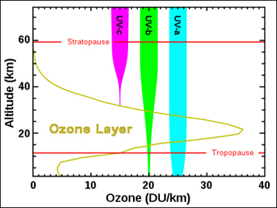
Stratospheric Ozone. The chart at the left shows the amount of ozone (yellow line) mainly in the stratosphere. The peak ozone density is about 20 to 25 kilometers (about 14 miles) high. There are three types of ultraviolet rays radiated from the sun UV-a, UV-b, and UV-c. UV-c (purple) is entirely screened out by the ozone around 35 kilometer altitude. Most UV-a (blue) reaches the surface but it is not very damaging. It is the UV-b (green) radiation that causes sunburn and can also cause genetic damage, resulting in skin cancer with prolonged exposure. Ozone screens out most UV-b, but some reaches the surface. It is critical that the ozone layer remains constant as more UV-b would reach the earth if it were to decrease. Bottom line - ozone in the stratosphere is a very good thing!
This stratification, with warmer layers above and cooler layers below, makes the stratosphere very stable, i.e. there is no regular convection and associated turbulence in this part of the atmosphere. Commercial jet airplanes typically cruise at altitudes of 30,000 to 39,000 feet (about 6 to 7 miles high) at the bottom of the stratosphere. They do this to optimize fuel because the low air density reduces drag. It also allows them to stay above inclement weather. Top
What Are Sprites?
Sprites, sometimes called red lightning, are massive flashes that occur directly above an active thunderstorm on earth and happen at the same time as normal cloud-to-ground or intra-cloud lightning strikes. The name, red sprites, originated from the words "air spirits".
Sprites are found high up in the "Mesosphere" from about 30 miles to 60 miles high. For comparison, normal lightning occurs from the earth to about 6 miles above. Not every lightning strike generates a corresponding sprite. It is believed that a sprite occurs about once every thousand normal strikes. The basic sprite physical and chemical processes are not well understood. As a result NASA has placed a package of sensors (project Firestation) on board the International Space Station to learn more about them.
Note the photo to the left of red sprites as seen by the naked-eye (a rare occurance) over Kansas in April, 2019. Sprites last for just a few milliseconds so it is not easy to see or capture them on film. Veteran sprite chaser Paul Smith who took the sprite picture to the left says he "did see them". "I've watched a number with my bare eyes over the last two big storms in Kansas."
Sprites were first photographed 30 years earlier in July, 1989 when scientists from the University of Minnesota, using a low-light video camera, accidentally captured the first image of them. Although sprites had been reported for at least a century, many scientists did not believe they actually existed until 1989 when they were suddenly photographed and then were confirmed by video cameras on board the space shuttle.
The Troposphere - Our Living Layer
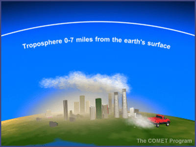
The troposphere begins at the earth's surface and extends to between 30,000 feet (about 6 miles) at the poles and 56,000 feet (10.6 miles) at the equator, with some variations due to weather. See the picture of the troposphere at the left taken from an airliner. The troposphere is heated chiefly by the transfer of energy from the earth's surface. The sun's heat that warms the surface is transported upwards mostly by convection (transfer of heat by movement of fluids such as air) and is mixed by updrafts and downdrafts. This promotes vertical churning (hence the origin of the name, trope, meaning "mixing" in Greek).
The lowest part of the troposphere is warmest and temperature decreases with altitude. The troposphere layer ends at the point where temperature no longer varies with height, thus the tropopause is the boundary between the troposphere and stratosphere. The tropopause is the beginning of an inversion layer and therefore there is little mixing between these two layers of the atmosphere. The troposphere contains roughly 80% of the mass of the atmosphere. The chemical composition of the troposphere is very uniform, with the notable exception of water vapor.
Since the temperature of the troposphere decreases with height, the amount of water vapor that can exist in the atmosphere strongly decreases with height. Thus water vapor is normally greatest near the surface.
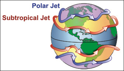
The air is much drier above the tropopause (the top of the troposphere) in the stratosphere. And in general, winds are strongest under the tropopause except during tornadoes or hurricanes. Winds increase with height up to the jet streams. Jet streams are fast flowing, narrow (one to three miles thick) air currents near the tropopause.
Most people think there is only one jet stream, but there are really four, two in the northern hemisphere and two in the southern as seen at the left. The major jet streams are westerly winds, flowing west to east. Their paths typically have a meandering shape. Jet streams are caused by the planet's rotation on its axis and atmospheric heating from solar radiation.
Tropospheric Ozone. About 90% of the atmospheric ozone is found in the stratosphere while the remaining 10% is in the troposphere. Ozone is scarce in the troposphere with concentrations of only 0.02 to 0.3 parts per million, but even in these small doses this molecule can do a lot of damage. Ozone in the troposphere is one of the greenhouse gases. As discussed in the Greenhouse Effect, the naturally occurring greenhouse gases (including ozone) in the stratosphere are what makes earth habitable for life as we know it.
The two major sources of natural ground level ozone are hydrocarbons, which are released by plants and soil, and small amounts of stratospheric ozone, which occasionally migrate down to the earth's surface. Neither of these sources contributes enough ozone to be considered a threat to the health of humans or the environment. But scientists are very concerned about the warming effects of increased greenhouse gases caused by human activity. So in the troposphere, increased ozone levels are a double whammy - a key ingredient greenhouse gas and a powerful smog element.
Tropospheric ozone is formed by the interaction of ultraviolet sun light with hydrocarbons and nitrogen oxides, which are emitted by automobiles, fossil fuel power plants, refineries, and other industries. Tropospheric ozone, or bad ozone, is an air pollutant that injures or destroys living tissue, vegetation, nylon, rubber, and other materials. Some elastic materials can become brittle and crack, while paints and fabric dyes may fade more quickly. Ozone affects plants in several ways. High concentrations of ozone cause plants to close their stomata. These are the cells on the underside of the plant that allow carbon dioxide and water to diffuse into the plant tissue. This slows down photosynthesis and plant growth. The amount of ozone present in the troposphere varies from day to day and from place to place. We have reason to be concerned about the buildup of ozone in the troposphere. Top
Oxygen Carbon-Dioxide Cycle
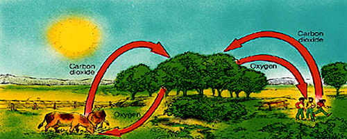
The oxygen carbon-dioxide cycle is a continuous process whereby animals inhale oxygen and exhale carbon dioxide. Plants then inhale the carbon dioxide and exhale oxygen. Plants consume carbon dioxide during "photosynthesis" and produce oxygen as a waste product. Carbon dioxide is absorbed from the air by the leaves of plants. Oxygen is expelled into the air from plants also through their leaves.
All living bodies (frogs, fish, reptiles, animals, and humans) get their energy from a process called "cellular respiration". Energy is released from the sugar molecules found in food. Cellular respiration breaks up large molecules (sugar and starches) into smaller molecules releasing energy in the process. Oxygen is consumed during cellular respiration and carbon dioxide is a waste product. The carbon dioxide produced during cellular respiration is consumed in photosynthesis. The oxygen produced during photosynthesis is consumed back in cellular respiration. This completes the oxygen carbon-dioxide cycle. Top
Atmospheric Carbon Cycles
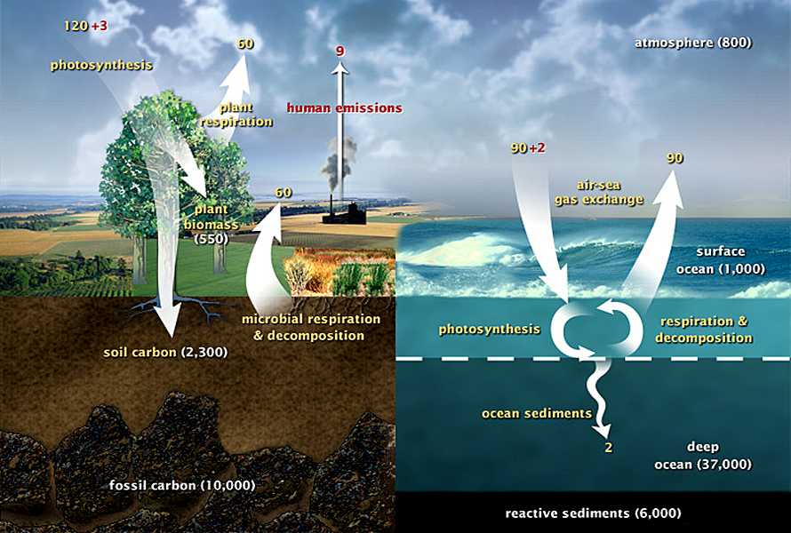
The above diagram of carbon cycles shows the movement of carbon between the atmosphere, land and oceans. The yellow numbers are "natural" yearly flows (fluxes), and red ones are "human" flows in Gigatons of Carbon (GtC) per year. The white numbers indicate the amounts of stored carbon in various areas. There are two major atmospheric carbon sub-cycles: one over land, and the other over water. (Diagram and data from the US Department Of Energy).
Carbon Cycle Over Land
The main way carbon moves out of the atmosphere is by photosynthesis from trees, plants, and other forms of brush. Photosynthesis consumes 123 GtC per year but during the process also returns 60 GtC back into the atmosphere. 60 GtC is also returned by microbes, animals, and other living organisms including decomposition. The mini cycle between plants and living organisms is basically in balance at 120 GtC per year plus an additional 3 GtC of human generated carbon is removed. Humans, however, are adding 9 GtC per year of carbon mainly through through the burning of fossil fuels. Therefore from the land carbon cycle the net addition from humans is 6 GtC.
A proportion of the carbon from the carbon cycle is stored by living plants (550 GtC). Some carbon gets buried (3 GtC per year) and stored in the soil (2,300 GtC), where it can stay for a long time. Some plants never completely decompose and form fossil fuels (10,000 GtC) like coal. oil, and natural gas.
Carbon Cycle Over Oceans
Similar to the cycle of atmospheric carbon over land, carbon over the oceans is almost in balance exchanging about 90 GtC between the atmosphere and the water. The oceans are absorbing an additional 2 GtC of carbon more than they are expelling which becomes part of the ocean sediment. These sediments fall to the deep waters and then eventually settle into sedimentary rock on the ocean floor. These ocean floor sedimentary rocks store about 6,000 GtC of carbon.
The surface waters (about 10 meters deep) contain a lot of tiny phytoplankton (microscopic plant organisms such as algae). Phytoplankton (ocean plants) take carbon dioxide from the atmosphere by absorbing it into their cells, similar to plants on land. Using energy from the sun, plankton consume carbon dioxide and water to form sugar and oxygen. About 50% of the total oxygen in the atmosphere originally came from phytoplankton. We humans owe our existence to these tiny plants. In summary, humans are polluting the atmosphere with about 9 GtC a year. Land photosynthesis is removing 3 GtC and the oceans likewise 2 GtC of carbon. That leaves a net increase of carbon in our atmosphere each year of 4 GtC, which has been increasing for many, many years. Top
Atmospheric Circulation
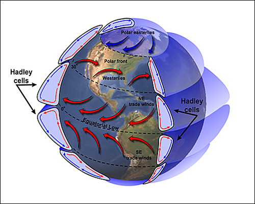
Atmospheric circulation is the large scale movement of air that over time transfers thermal energy from the warm equator to the cold poles. The wind belts girding the planet are organized into three cells: the Hadley cells, the Ferrel cells (shown in red to the left), and the Polar cells (in dark blue).
Hadley cells, first described by George Hadley, are circulation loops that begin at the equator with warm, moist air from low pressure equatorial areas. They rise up to the top of the atmosphere and make their way towards both poles. At about 30° north and south latitudes, they cool somewhat and descend into high pressure relatively dry areas. Some of the "descending" air travels west equatorially over the earth's surface creating the "Trade Winds" and completing the loop of the cells.
Polar cells are air masses that initiate at approximately both 60th parallels. Relatively warm air rises and moves through the upper atmosphere towards the poles. When the air reaches the polar regions, it has cooled considerably and descends as a cold, dry, high pressure system moving westward along the surface away from the poles.
The Ferrel cell, theorized by William Ferrel, is a secondary cell that depends for its existence upon the Hadley and the Polar cells. In the Northern Hemisphere at its southern edge, the Ferrel cell overrides the direction of the Hadley cell, and at its northern edge it overrides the direction of the Polar cell. Just as the Trade Winds can be found at the lower heights of the Hadley cell, the Prevailing Westerlies can be found at the lower heights of the Ferrel cell. However, one significant difference is that the Ferrel cell is generally not a closed loop system. While upper level Prevailing Westerlies move essentially from west to east, surface winds can vary abruptly in direction. A cold front can change the direction of surface winds in a matter of minutes and frequently does.
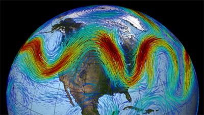
Rossby Waves (pictured to the left) are large atmospheric undulations that are associated with the polar jet streams. They separate cold polar air from warm tropical air. Rossby Waves form in rotating fluids in the atmosphere (and in the oceans). They are large-scale waves that meander through the atmosphere high above earth's surface. The waves are named for Carl Arvid Rossby, who first identified them and explained their movements.
Rossby Waves are formed when polar air moves toward the equator while tropical air is moving pole-ward. Because of the temperature differences between the equator and the poles (due to different amounts of solar radiation received) heat tends to flow from lower equator latitudes to higher polar latitudes. This is accomplished (in part) by Rossby Waves.
Rossby Waves are a dominant component of the Ferrel cell circulation. The tropical air carries heat pole-ward, and the polar air absorbs heat as it moves toward the equator. Jet-stream winds generally travel at the same latitudes and can shift into wave-like patterns. Rossby waves meander from north to south and back again. When this happens, warm air fills the peaks of the wave, while cold polar air drops into the troughs
The terms "barotropic" and "baroclinic" are used to distinguish the vertical structure of Rossby waves. Barotropic Rossby waves do not vary vertically and have the fastest propagation speeds. The baroclinic wave modes, on the other hand, do vary in the vertical. They are slower with speeds of only a few centimeters per second.
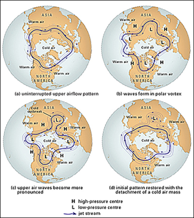
Rossby waves in the earth's atmosphere are easy to observe as sub-systems meander from the jet stream. See the polar diagrams to the left. When these deviations become pronounced, masses of warm or cold air can detach and become low-strength cyclones or anticyclones. See the low-peressure cyclone over Asia formed in the 3rd and 4th diagrams to the left. These sub-systems are responsible for the day-to-day weather patterns at mid-latitudes.
The existence of these Rossby Waves explain the low-pressure cells (cyclones) and high-pressure cells (anticyclones) that are important in producing the weather in the middle and higher latitudes.
The action of Rossby waves partially explain why eastern continental edges, such as the Northeastern United States and Eastern Canada, are colder than similar Western Europe regions at the same latitude. Top
Atmospheric Rivers
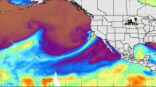
Atmospheric rivers are relatively long, narrow regions in the atmosphere that transport water vapor from the tropics to the western part of the United States. See the weather map to the left from February 17, 2017 which shows an atmospheric river dumping a ton of rain on Northern California causing many flooded areas. (Do you remember the February, 2017 Oroville Dam crisis?) The term was originally coined by researchers, Reginald Newell and Yong Zhu of MIT in the early 1990s, to reflect the narrowness of the moisture plumes involved.
These narrow columns of water vapor move with the weather and carry an amount of water up to 15 times the average flow of water at the mouth of the Mississippi River. When the atmospheric rivers make landfall, they usually release the water vapor in the form of huge rain or snow storms. A well known example is the "Pineapple Express," a strong atmospheric river that is capable of bringing moisture from the tropics near Hawaii to the US West Coast.
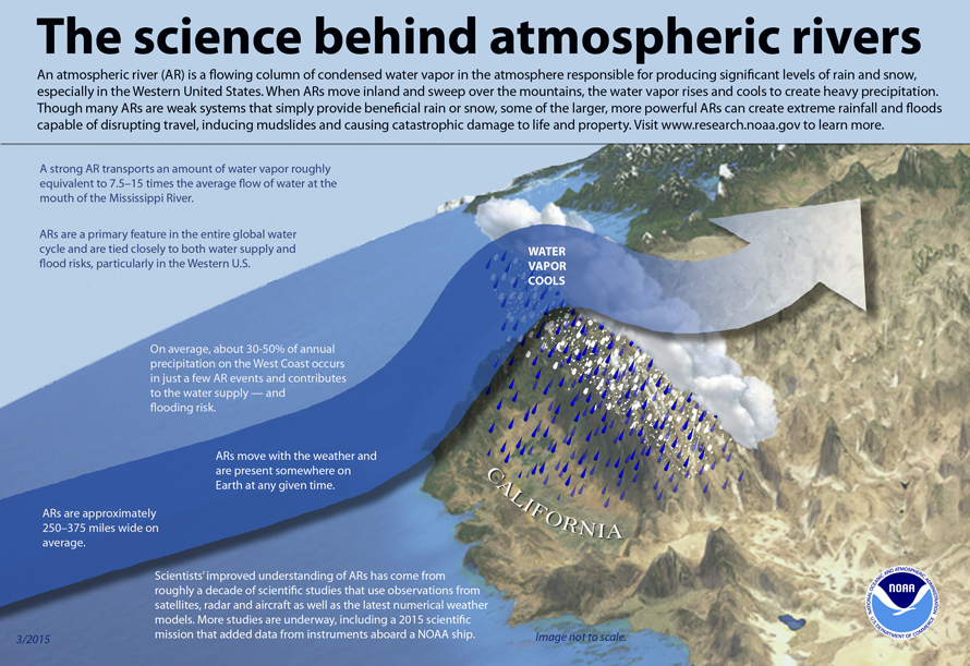
A study released in February, 2017 in the peer-reviewed British journal Nature Geoscience, said it is not only the USA that sees these weather trouble makers. Globally, up to 75% of extreme precipitation events come from atmospheric rivers, said study lead author Duane Waliser, an atmospheric scientist at NASA's Jet Propulsion Laboratory. In western Canada, Northern Europe, New Zealand and Southern South America, atmospheric rivers occur on 30 to 35 days per year, Waliser said. Though beneficial for water supplies in the western USA, these events can wreak havoc for travel, bring deadly mudslides and cause catastrophic damage to life and property, NOAA (the US National Oceanic and Atmospheric Administration) explained.
Top